In business for over 25 years, Global Surveying Consultants, Inc. is a full-service land surveying firm, based in the metropolitan area of North Little Rock, Arkansas and serving clients nationwide. Our dedicated team has over 60 years of combined experience, and has performed all types of surveys and design for governmental agencies, the communication industry, title companies, private landowners and developers.
We use the latest in electronic surveying instruments along with global positioning systems for the highest accuracy and a shorter time from field to finish. Our mapping and drafting department uses the most up to date industry softwares to produce clean legible drawings that are compatible with most other systems.
The Global Surveying Consultants, Inc. Story
Global Surveying Consultants, Inc. was founded in 1984 as Ben Kittler Jr., Surveying Company in Bryant, Arkansas, and provided surveying services to nearby municipalities and local developers. Since that time we have increased our ability to offer these services to a wide range of clients nation-wide.We have maintained and increased our local staff to better serve your needs. Also, we have networked and updated our computer systems to speed “in-house” production, this not only reduces costs to the client but increases the quality of the product delivered. Global Surveying Consultants, Inc. is a full service land surveying firm based in the metropolitan area of Little Rock, Arkansas. With over 60 years combined experience we have performed surveys of all kinds for government agencies, communication industries, and title companies as well as the private sector.
Some of our services include Boundary, Topographic, Civil, Geodetic, Hydrographic, Forensic, ALTA/ACSM, Cadastral, Construction, and Route Surveying as well as flood plain, 1A, and 2C location accuracy certifications.
The GSC Difference
In addition to our commitment to client satisfaction, Global Surveying Consultants’ difference is the quality in the details in our surveys. In many cases, the difference in the level of information you receive and use for planning your project can translate into a difference in investment costs to you.
In addition to abiding by the Minimum Standards for Property Boundary Surveys, as required by the Division of Land Survey, we use an internal checklist that includes additional survey details, depending upon the project requirements. Our details are legible and thus, useful to you in your project.
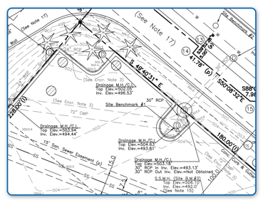
Example of the quality we include in our survey maps:

